Mount Kilimanjaro rises from the East African plains like a geographic impossibility—a snow-capped giant just 330 kilometers south of the equator. This positioning creates one of nature’s most striking contrasts: permanent glaciers shimmering above tropical savannas, arctic conditions hovering over elephant migration routes.
Understanding where Kilimanjaro sits—and why its location matters—transforms it from a pin on a map into a strategic starting point for your expedition.
Location: Kilimanjaro Region, northeastern Tanzania
Coordinates: 3.0764°S, 37.3556°E
Distance from equator: 330 km (205 miles) south
Distance from Nairobi: 300 km south
Distance from Dar es Salaam: 530 km northwest
Distance from Indian Ocean: 320 km inland
The mountain sits entirely within Kilimanjaro National Park (established 1973, covering 1,688 square kilometers), which protects everything from the montane forest belt upward. Below park boundaries, the Chagga people have farmed the volcanic slopes for centuries.
While Kilimanjaro’s northern approaches near the Kenya border—the Rongai Route starts just kilometers away—the entire mountain lies within Tanzanian territory. All climbing happens under Tanzanian regulations, period.
Kilimanjaro rises from the East African Plateau, a broad upland region covering much of East Africa at elevations between 900 and 1,800 meters above sea level. The surrounding plains, dominated by savanna grasslands and acacia woodlands, stretch endlessly in most directions, making Kilimanjaro’s dramatic vertical rise even more visually striking.
Kilimanjaro’s formation relates directly to the East African Rift System, one of Earth’s most significant geological features. This massive rift system, where the African continent is slowly splitting apart, runs from the Red Sea through East Africa to Mozambique. Volcanic activity associated with rifting created Kilimanjaro and many other East African volcanic mountains including Mount Meru, Mount Kenya, and the Virunga Mountains.
The Rift Valley’s influence on Kilimanjaro extends beyond its volcanic origins. The rift system affects regional weather patterns, creating the climatic conditions that allow glaciers to persist at equatorial latitudes. Additionally, the rift’s tectonic activity continues today, meaning Kilimanjaro exists in a geologically active region, though the mountain itself has been dormant for thousands of years.
The landscape around Kilimanjaro features striking contrasts. To the west, about 70 kilometers away, stands Mount Meru, Tanzania’s second-highest peak at 4,566 meters. Its conical shape offers stunning views from Kilimanjaro’s western slopes, and many climbers acclimatize on Meru before tackling Kilimanjaro.
To the east and south, the terrain gradually descends to the Pangani River basin and the Indian Ocean coast, roughly 320 kilometers away. From Kilimanjaro’s northern slopes, visitors can see Kenya’s Amboseli National Park, famous for its elephant herds.
South of Kilimanjaro lies the Maasai Steppe, which transitions into the Serengeti ecosystem, known for its rich wildlife. This closeness allows travelers to combine Kilimanjaro climbs with safari experiences, creating a popular adventure option.

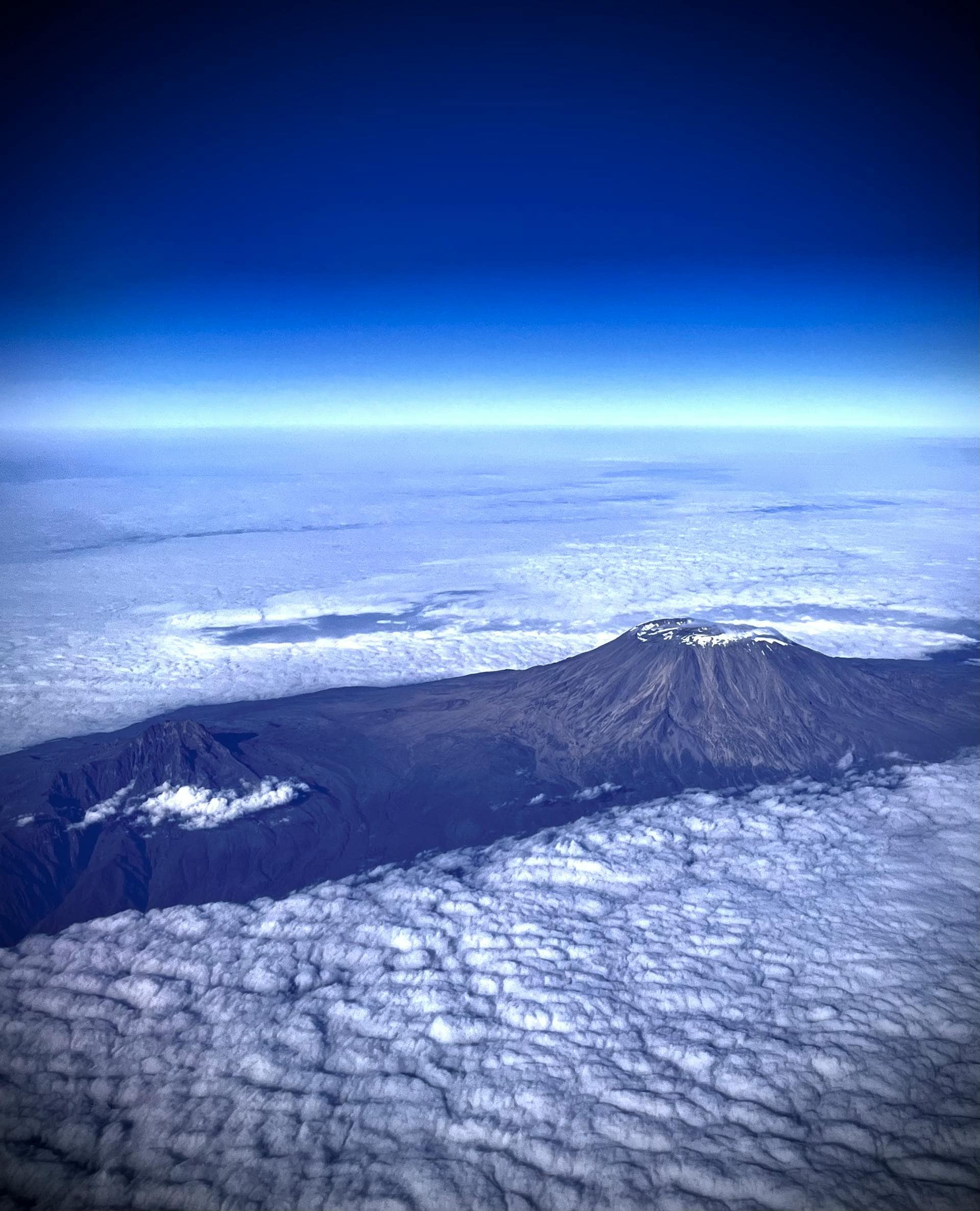
Understanding Kilimanjaro’s location requires recognizing it’s not a single peak but rather a volcanic massif comprising three distinct cones, each with its own geographical position and characteristics.
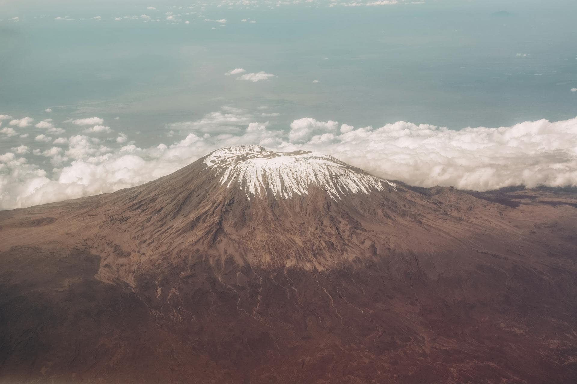
Kibo, the youngest and highest cone, reaches 5,895 meters at Uhuru Peak—Africa’s highest point. Kibo occupies the center of the Kilimanjaro massif and forms the mountain’s iconic snow-capped summit that defines its global image. Kibo’s summit features a crater approximately 2.5 kilometers in diameter containing the Reusch Crater, a smaller nested crater that itself contains a central ash pit.
Kibo’s glaciers and ice fields, though rapidly receding due to climate change, remain Kilimanjaro’s most distinctive feature. These glaciers—including the Northern Ice Field, Southern Ice Field, and others—exist because Kibo’s high elevation creates arctic conditions despite equatorial location.
Mawenzi, located about 5 kilometers east of Kibo, reaches 5,149 meters at its highest point (Hans Meyer Peak). Unlike Kibo’s dome-like profile, Mawenzi features dramatic, jagged peaks and steep rock faces created by extensive erosion. Mawenzi is significantly older than Kibo, and volcanic activity ceased long ago, allowing erosion to carve its distinctive rugged appearance.
Mawenzi is visible from many Kilimanjaro routes, particularly those approaching from the east or traversing the saddle between Kibo and Mawenzi. Its dramatic spires create spectacular photographic subjects and provide technical climbing opportunities for experienced mountaineers, though it’s not part of standard Kilimanjaro trekking routes.
Shira, the oldest cone, collapsed roughly 500,000 years ago, creating the Shira Plateau on Kilimanjaro’s western side. This broad, relatively flat plateau sits at approximately 3,800 meters elevation and spans about 13 kilometers across. The plateau’s volcanic origins are evident in its lava formations, volcanic rock fields, and the Shira Cathedral—a dramatic rocky outcrop rising from the plateau.
The Shira Plateau provides spectacular trekking for routes approaching from the west (Lemosho, Shira). Its open, moon-like landscapes offer incredible views and excellent acclimatization opportunities. The plateau represents what remains of Shira’s original volcanic cone after catastrophic collapse eons ago.
Kilimanjaro rises from the East African Plateau (900-1,800m elevation), surrounded by savanna grasslands and acacia woodlands stretching endlessly in every direction. This dramatic vertical relief—approximately 4,900 meters from base to summit—ranks among Earth’s highest prominence ratios.
Mount Meru (4,566m) stands 70 kilometers west, Tanzania’s second-highest peak and a perfect acclimatization climb. Many climbers tackle Meru first, enjoying spectacular Kilimanjaro views from its slopes.
To the north: Kenya’s Amboseli National Park, where elephants roam with Kilimanjaro as backdrop—arguably Africa’s most photographed vista.
To the south: The Maasai Steppe transitioning toward the Serengeti ecosystem, enabling popular climb-and-safari combinations.
To the east: The land descends toward the Pangani River basin and eventually the Indian Ocean, 320 kilometers distant.
Population: ~185,000
Elevation: 890m
Distance from summit: 30km (direct line)
Moshi is Kilimanjaro central. This bustling town on the southern slopes hosts hundreds of tour operators, equipment shops, hotels, restaurants, and everything a climber needs. Its proximity to major routes (Machame, Umbwe, Marangu) and moderate elevation makes it the logical pre-climb base.
When clouds permit, Kilimanjaro dominates Moshi’s northern skyline—a constant reminder of what’s coming. The town’s infrastructure supports comprehensive expedition preparation and post-climb recovery, from gear checks to celebratory dinners.
Distance from Kilimanjaro Airport: 40km (1 hour drive)
Population: ~617,000
Elevation: 1,400m
Distance from Kilimanjaro: 80km southwest
Arusha offers more extensive accommodation and services than Moshi, plus higher elevation for better pre-climb acclimatization. As northern Tanzania’s safari headquarters, it’s ideal for combining Kilimanjaro with Serengeti or other northern circuit attractions.
Most climbers still prefer Moshi’s proximity and mountain-focused atmosphere, but Arusha works well for multi-destination itineraries.
Distance from Kilimanjaro Airport: 50km
Located 25 kilometers from Moshi at ~1,500m elevation, this small Chagga village sits at the Marangu Route’s base. Limited guesthouses cater primarily to Marangu climbers, while cultural tours explore traditional Chagga life, waterfalls, and coffee plantations—excellent pre-climb or post-climb activities.
Kilimanjaro’s location in East Africa, while remote by global standards, is remarkably accessible compared to many other major peaks.
Kilimanjaro International Airport (JRO): This dedicated international airport, located between Moshi and Arusha, receives direct flights from Amsterdam (KLM), Doha (Qatar Airways), and seasonal flights from other European cities. Most travelers from North America, Asia, or Australia connect through these hubs or through Nairobi, Kenya.
Julius Nyerere International Airport (DAR): Dar es Salaam’s main airport offers more international connections than Kilimanjaro Airport but requires an additional domestic flight or long drive (8-10 hours) to reach Moshi. Some travelers use Dar es Salaam for better flight connections, particularly from southern Africa or Asia.
Jomo Kenyatta International Airport (NBO): Nairobi, Kenya’s main airport, offers excellent global connections and sits only 300 kilometers from Kilimanjaro. However, crossing the Tanzania-Kenya border adds complexity. Some travelers fly to Nairobi then take shuttle buses to Moshi (4-6 hours), while others book connecting flights to Kilimanjaro Airport.
Once in Tanzania, several transportation options connect airports to Moshi or Arusha:
Private Transfers: Most tour operators include airport transfers in packages. Private vehicles provide convenient, direct transportation from Kilimanjaro Airport to Moshi (45-60 minutes) or Arusha (45-60 minutes).
Shuttle Buses: Shared shuttle buses operate between airports and both cities, offering economical options for budget travelers. However, schedules are less flexible than private transfers.
Rental Vehicles: Self-driving is possible for experienced travelers comfortable with Tanzanian driving conditions, though most climbers prefer arranged transportation avoiding navigation and parking challenges.
Different routes begin at different points around the mountain:
Machame Gate: Southern approach, accessed from Moshi via rough roads requiring 1-2 hours’ drive
Marangu Gate: Southeastern approach, accessed from Moshi through Marangu Village, approximately 1 hour’s drive
Londorossi Gate: Western approach for Lemosho and Shira routes, accessed from Moshi via 3-4 hours’ drive around the mountain’s western side
Rongai Gate (Nalemuru): Northern approach, accessed from Moshi via 3-4 hours’ drive around eastern then northern sides
These varying access points mean your route selection affects not just your climbing experience but also the journey to your starting point. Remote routes like Rongai and Lemosho involve longer drives on rougher roads but offer quieter climbing experiences.
Kilimanjaro’s location within Africa gives it tremendous cultural, economic, and ecological significance beyond its physical geography.
For the local communities, especially the Chagga people living on Kilimanjaro’s southern slopes, the mountain holds a significance that goes beyond being just a geographic feature. It is revered as sacred within their traditional beliefs, serves as a vital source of water, and boasts fertile volcanic soils that support their agricultural livelihoods. Moreover, as tourism grows, Kilimanjaro is increasingly becoming a key source of economic opportunity.
Throughout history, the mountain’s towering presence has made it a notable landmark for traders, explorers, and travelers. For centuries, Arab and Swahili traders relied on Kilimanjaro as a navigational guide while venturing inland from the coast. In the 19th century, European explorers became fascinated with this enigmatic, snow-capped peak, culminating in Johannes Rebmann’s so-called “discovery” in 1848 from a European viewpoint and Hans Meyer’s successful ascent in 1889.
Kilimanjaro’s strategic location in northeastern Tanzania makes it an ideal hub for tourism development. This majestic mountain generates significant revenue for the country through park fees, creates employment in various tourism services, and provides substantial indirect economic benefits to surrounding communities. The Kilimanjaro Region thrives on mountain tourism, which cultivates tens of thousands of jobs and drives local development.
Moreover, Kilimanjaro’s close proximity to other stunning northern Tanzania attractions—such as the Serengeti, Ngorongoro Crater, Lake Manyara, and Tarangire—facilitates seamless tourism circuits. Many visitors enhance their travel experience by combining Kilimanjaro climbs with unforgettable safari adventures, extending their stays and maximizing their economic impact.
Kilimanjaro’s location and elevation create an “island” ecosystem hosting unique biodiversity. The mountain’s vertical zonation from tropical base to arctic summit encompasses ecosystems found nowhere else at these latitudes. Species adapted to Kilimanjaro’s unique conditions include endemic plants and animals existing only on this mountain.
The mountain serves as crucial water catchment for surrounding regions. Rainfall and snowmelt feed rivers flowing in all directions, supporting agriculture, wildlife, and communities far from the mountain. Kilimanjaro’s ecological health directly impacts regional water security, making its conservation critically important beyond tourism considerations.
Being near the equator means:
But equatorial doesn’t mean stable. The Intertropical Convergence Zone (ITCZ) shifts seasonally, creating distinct wet and dry periods as moisture-laden air moves north and south.
Maritime weather from the Indian Ocean, 320 kilometers east, drives monsoon patterns:
The ocean’s moderating influence prevents extreme temperature swings at lower elevations, though summit temperatures remain brutally cold due to altitude.
Kilimanjaro creates its own weather. The massive bulk forces air upward to cool, producing orographic precipitation. Southern and eastern slopes (facing prevailing winds) receive more rainfall than northern and western slopes in the rain shadow.
No technical climbing skills are required. Kilimanjaro is fundamentally a challenging high-altitude trek rather than a technical mountaineering expedition. You won't need ropes, ice axes, or crampon experience. However, don't underestimate the challenge—you'll need excellent cardiovascular fitness, mental resilience, and the ability to walk six to eight hours daily at high altitude while carrying a daypack. The difficulty comes from altitude, not technical climbing.
Begin training at least four to six months before your climb. Focus on building aerobic endurance through hiking, running, cycling, or swimming, aiming for four to five cardio sessions weekly. Include strength training for legs, core, and back muscles. Long hikes with elevation gain while carrying a 5-8 kilogram weighted backpack prove particularly valuable. High-intensity interval training can also improve your VO2 max, helping your body utilize oxygen more effectively at altitude.
Acute mountain sickness (AMS) is the primary reason climbers fail to reach Uhuru Peak. As you ascend, atmospheric pressure decreases and less oxygen enters your bloodstream. The key to preventing this is choosing longer routes—seven or eight-day itineraries have success rates of 85-95%, while shorter five or six-day routes often have success rates below 70%. The extra acclimatization days dramatically improve your chances of standing atop Africa.
our tour operator choice significantly impacts your experience, success rate, and crew welfare. Prioritize companies with strong ethical practices that pay fair wages, provide proper equipment for porters, and maintain quality gear. Look for operators certified by organizations like the Kilimanjaro Porters Assistance Project (KPAP). Experienced guides with wilderness first aid training, excellent English, and hundreds of summits make an enormous difference. Don't choose based solely on price—rock-bottom costs usually mean corners are cut in porter welfare, food quality, or equipment.
Summit night is the most physically and mentally demanding part of your climb. You'll wake around 11:00 PM and begin trekking around midnight, climbing through darkness toward Uhuru Peak for sunrise. The ascent takes six to eight hours, covering roughly 1,200 meters of elevation gain in temperatures often dropping to minus 20 Celsius. Progress is excruciatingly slow—one step, two breaths, another step—as the thin air contains roughly half the oxygen available at sea level. Mental toughness becomes paramount as you battle nausea, headaches, extreme fatigue, and penetrating cold.
Aim to drink four to five liters of water daily at altitude. Adequate hydration directly impacts acclimatization, helps prevent altitude sickness, reduces headaches, and aids physical performance. Your urine should remain clear or pale yellow—dark urine signals dehydration, which exacerbates altitude problems. This may seem like an excessive amount, but proper hydration is one of the most important factors in your summit success.
The descent presents significant challenges that are often underestimated. More accidents occur during descent than ascent due to fatigue, relaxed concentration, and pounding impact on knees and toes. After summiting, you'll descend to high camp for brief rest before continuing to a lower camp—meaning you might trek 12-16 hours on summit day. Trekking poles prove invaluable for protecting your knees on steep descents through loose volcanic scree. Most routes complete the final descent the day after summit night, returning through moorland and rainforest to the park gate where you'll receive your official summit certificate.
We believe adventure should inspire, not exploit. Every expedition we guide creates meaningful employment for local families, supports community development, and preserves the natural wonders we’re privileged to explore.
* Sign up to receive curated travel ideas, seasonal discounts.
Copyright © 2025 All Rights Reserved.