Kilimanjaro’s weather defies simple explanation. One morning you’re sweating through equatorial rainforest at 25°C; three days later you’re battling -25°C winds on an arctic summit. Understanding these dramatic shifts—and the forces driving them—separates prepared climbers from struggling ones.
This guide reveals everything about Kilimanjaro’s weather patterns and five distinct climate zones, from the atmospheric forces shaping conditions to practical strategies for each elevation.
Just 330 kilometers south of the equator, Kilimanjaro experiences:
But equatorial doesn’t mean stable. The Intertropical Convergence Zone (ITCZ)—where northern and southern hemisphere trade winds meet—migrates seasonally, creating Kilimanjaro’s wet and dry periods:
Kilimanjaro sits 320 kilometers from the Indian Ocean. Monsoon winds transport maritime moisture inland:
Southeast Monsoon (March-May): Heavy moisture transport creates the long rains. Moist air hits Kilimanjaro’s bulk, rises, cools, and releases precipitation—primarily on southern and eastern slopes.
Northeast Monsoon (November-December): Less intense moisture transport produces the short rains.
Dry Season Winds: Continental air masses dominate, reducing ocean moisture transport significantly.
Kilimanjaro’s massive size forces air upward. Rising air cools ~6-10°C per 1,000m elevation gain. As air cools, moisture condenses into clouds and precipitation.
Result:
Temperature decline: ~6-7°C per 1,000m elevation gain. When Moshi enjoys 25°C, Uhuru Peak simultaneously endures -15°C.
Atmospheric pressure: At 5,895m, pressure is ~50% of sea level—affecting oxygen, cloud formation, and weather behavior.
UV radiation: 50-60% higher at summit than sea level due to thinner atmospheric filtering.
Extreme temperature swings: 30-40°C daily fluctuations at high camps—daytime warmth to nighttime extreme cold.
Daytime: 20-30°C year-round, warmest during dry seasons
Nighttime: 12-20°C, comfortable even in coolest months
What it feels like: Tropical warmth. Most climbers start in short sleeves, adding layers as elevation increases.
Daytime: 15-25°C, moderated by forest canopy
Nighttime: 5-15°C, occasionally near-freezing at upper elevations in June-August
What it feels like: Humid and cool. Rainfall frequent. Layering becomes important.
Daytime: 5-20°C with significant variation. Sunny days feel warm despite cool air; cloudy days bitter cold.
Nighttime: -5 to +5°C, regular freezing
What it feels like: “Summer every day, winter every night.” Pleasant daytime trekking, but nights require warm sleeping bags.
Daytime: -5 to +10°C, varying dramatically with sun exposure
Nighttime: -15 to -5°C, consistently below freezing
What it feels like: Harsh. Direct sunlight feels warm, but shade or clouds bring bitter cold. High camps (Barafu, Kibo Hut) are brutal—cold, windy, difficult to rest.
Summit night climbing hours: -20 to -10°C
Wind chill: Can drop feels-like temperature to -30 to -40°C
What it feels like: The coldest conditions most climbers will ever experience. Proper cold-weather gear becomes life-or-death critical.
Long Rains (March-May): Sustained heavy rainfall, especially lower/middle elevations. April is the wettest month. Upper elevations receive snow. Forest zones can exceed 300mm monthly precipitation.
Long Dry Season (June-October): Minimal precipitation across all elevations. Clear skies predominate. Forest zone rainfall drops to 20-50mm monthly. Prime climbing season.
Short Rains (November-December): Moderate precipitation, less intense than long rains. Afternoon showers common; mornings typically clear. 100-200mm monthly in forest zones.
Short Dry Season (January-February): Excellent weather rivaling June-October. Clear skies, minimal precipitation. Highly desirable for climbing.
Forest Zone (1,800-2,800m): 1,000-2,000mm annually—Kilimanjaro’s wettest zone
Heath/Moorland (2,800-4,000m): 600-1,000mm annually—moderate precipitation
Alpine Desert (4,000-5,000m): 200-400mm annually—mostly snow, true desert conditions
Summit Zone (5,000m+): Less than 200mm annually—all snow, extreme aridity
Southern/Eastern routes (Machame, Umbwe, Marangu): More precipitation due to windward exposure
Northern/Western routes (Rongai, portions of Lemosho): Drier due to rain shadow effects
Why it matters: Rongai recommended during shoulder seasons—stays relatively dry when southern routes face challenging wet conditions.
Lower elevations (below 3,000m): Light to moderate, 5-15 km/h. Forest canopy blocks wind.
Middle elevations (3,000-4,500m): 15-30 km/h. Exposed ridges offer little protection. Afternoon winds strengthen.
High elevations (4,500-5,895m): 30-50 km/h regularly, gusts exceeding 80 km/h during storms. Wind chill becomes critical for safety.
Summit night timing: Midnight-to-dawn departures partly avoid afternoon thermal updrafts that strengthen winds, though high-altitude wind remains unpredictable.
Clearest conditions of the day. Overnight cooling stabilizes atmosphere, clouds dissipate, winds lightest. Summit views most likely during early morning.
Why summit attempts start at midnight: Climbers reach summit at sunrise when conditions are optimal for views and safety.
Surface heating creates:
Why camps are reached by 2-3 PM: Before afternoon weather peaks.
Surface cooling brings:
Clear nights create coldest temperatures through radiative cooling. Cloudy nights stay warmer as clouds trap heat.
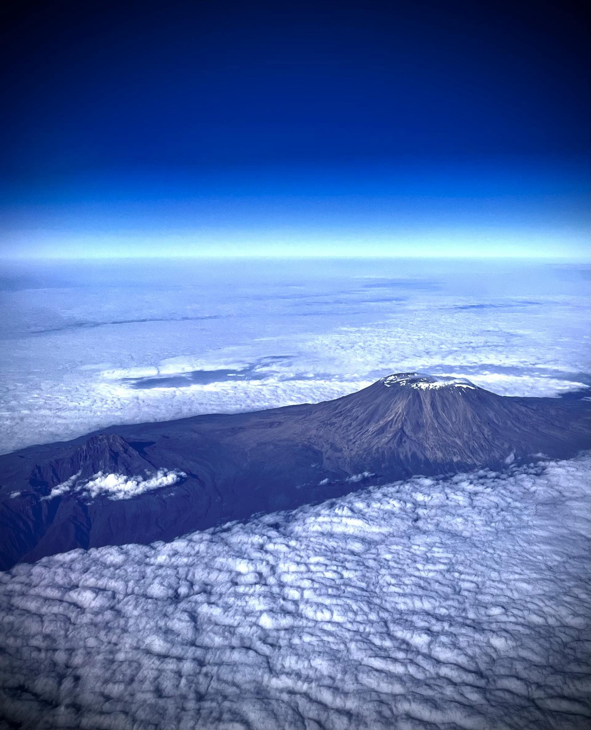
Kilimanjaro’s most remarkable feature isn’t height—it’s ecological telescoping. In five days, you’ll traverse the equivalent of traveling from the equator to the Arctic Circle. Understanding each zone prepares you for dramatically different worlds stacked vertically on one mountain.
Temperature: 20-30°C daytime, 12-20°C nighttime
Precipitation: 1,000-1,800mm annually
Climate type: Tropical savanna/highland
Centuries of Chagga agriculture have transformed natural ecosystems into multi-story farming systems: banana trees providing upper canopy, coffee shrubs in middle layer, vegetables at ground level. Elaborate irrigation channels (mfongo) demonstrate sophisticated water management developed over generations.
Wildlife: Limited to human-tolerant species—small mammals, birds (weavers, starlings, sunbirds), insects, occasional crop-raiding monkeys.
Transition point: Park boundary at ~1,800m marks where agriculture ends and protected forest begins.
Temperature: 15-25°C daytime, 5-15°C nighttime
Precipitation: 1,200-2,500mm annually—Kilimanjaro’s wettest zone
Climate type: Tropical montane
Ancient Ocotea and Podocarpus trees tower 30-40 meters, their branches festooned with epiphytes (mosses, orchids, ferns). Tree ferns create prehistoric ambiance. Perpetually wet conditions support incredible biodiversity.
Wildlife abundance:
Mammals: Colobus monkeys (spectacular black-and-white with long tails), blue monkeys, bushbuck, duiker, tree hyrax (eerie nighttime vocalizations), occasional elephants/buffalo in remote sections
Birds: Hartlaub’s turaco (spectacular green with red wing patches), silvery-cheeked hornbill, numerous sunbirds, cinnamon-chested bee-eater, hundreds of species including endemics
Insects: Extraordinary diversity—butterflies, beetles, countless species serving as pollinators, decomposers, and food sources
Trail conditions: Often muddy and slippery. Root-tangled paths require careful footing.
Atmosphere: Primordial and mysterious. Emerald-filtered light, bird calls, monkey vocalizations, dripping water. High humidity makes air feel heavy.
Sensory immersion: Endless green shades, rich earth smells, damp vegetation, cool temperatures—the forest announces you’re truly on the mountain now.
Temperature: 5-20°C daytime, -5 to +5°C nighttime with regular freezing
Precipitation: 600-1,000mm annually, increasingly as snow
Climate type: Alpine
Trees surrender around 2,800-3,000m, replaced by open moorland and Kilimanjaro’s most iconic plants:
Giant Groundsels (Dendrosenecio kilimanjari): Bizarre organisms evolved from daisy-family ancestors through remarkable adaptations:
Giant Lobelias (Lobelia deckenii): Compact rosettes with insulating fluid in leaf bases, dramatic 2+ meter flowering spikes
Heathers: Extensive shrubby heaths creating landscapes reminiscent of Scottish highlands—but at tropical latitudes
Mammals: Rock hyrax (related to elephants despite rodent appearance), occasional eland, Kilimanjaro mouse-eared bat, endemic four-striped grass mouse
Birds: Scarlet-tufted malachite sunbird (feeds on lobelia nectar), alpine chat, white-necked raven, augur buzzard
Trail conditions: Generally good, less mud than forest. Rocky sections increase. Open landscape allows seeing paths ahead—psychological benefit.
Atmosphere: Otherworldly. Sparse vegetation, volcanic rock, dramatic clouds, distant summit views. Profound silence—just wind and occasional raven calls.
Challenges: Altitude begins affecting most climbers. Temperature fluctuations require constant layering adjustments. UV radiation intensifies—sun protection critical.
Views: Spectacular. Giant groundsels create surreal landscapes, Kibo looms above, clouds float below, endless horizons. Stunning sunrises/sunsets.
Temperature: -5 to +10°C daytime, -15 to -5°C nighttime
Precipitation: 200-400mm annually, almost entirely snow
Climate type: Alpine desert/tundra
Extreme conditions:
Vegetation: Nearly absent. Lichens on rock surfaces, scattered mosses in sheltered spots, extremely rare tiny cushion plants.
Wildlife: Minimal but not entirely absent. Occasional leopards documented (one frozen carcass found near summit remains mysterious). Ravens soaring overhead. Spiders hunting windblown insects—remarkable survival strategy.
Trail conditions: Volcanic scree, ash, rock. Loose footing, especially on descent. Night freezing firms surfaces; daytime warmth loosens them.
Atmosphere: Utterly barren and hostile. No vegetation, no wildlife sounds—only wind and boot crunches on volcanic material. Profound emptiness creates psychological challenges.
Physical effects: Altitude affects everyone—breathlessness, headaches, reduced appetite, sleep difficulty, slower mental processing, general malaise.
High camps: Barafu (4,640m), Kibo Hut (4,703m) sit here. Exposed, uncomfortable, harsh. Most climbers spend minimal time—arrive afternoon, attempt sleep, depart midnight for summit.
Stark beauty: Despite harshness, dramatic volcanic formations, light playing on barren slopes, clouds below you, summit looming above create powerful aesthetics.
Temperature: -25 to -10°C during typical climbing hours (midnight-8 AM)
Precipitation: Less than 200mm annually, all snow
Climate type: Arctic at equatorial latitude—globally unique
Oxygen depletion: At 5,895m, atmospheric pressure ~50% of sea level. Each breath delivers half the oxygen. Your body cannot fully adapt—merely tolerates it temporarily before damage accumulates.
Extreme cold: Summit temperatures during climbing hours regularly hit -20 to -25°C. Wind chill pushes effective temperatures to -35°C or colder. Frostbite risk is real.
Maximum UV: ~60% higher than sea level. Snow/ice reflection doubles exposure. Severe sunburn occurs rapidly despite extreme cold.
Extreme aridity: Essentially zero humidity. Respiratory moisture loss is extreme—contributing to dehydration and discomfort.
Kibo’s ice fields define its global image:
Recession: From ~12 square kilometers (1912) to less than 2 square kilometers today. Projected complete disappearance by 2040-2060.
No plants grow, no animals reside permanently. Occasional windblown insects represent accidents, not inhabitants. Even microorganisms are sparse. One of Earth’s most hostile environments for biology.
Physical state: Most climbers are utterly exhausted. Hours at extreme altitude, in extreme cold, with minimal oxygen creates profound fatigue—breathlessness, severe headaches, nausea, confusion, numbness, overwhelming desire to descend.
Psychological impact: Despite exhaustion, powerful emotions—relief, joy, pride, awe, often tears. Extreme effort meeting profound achievement creates unforgettable moments.
Summit time: Guides limit stays to 15-30 minutes. Lingering risks cold injury and worsening altitude effects.
Views: On clear mornings, views extend hundreds of kilometers—across Tanzania to the Indian Ocean, into Kenya’s Amboseli, across the Maasai Steppe. The curved horizon creates profound perspective on your place in the world.
Zone boundaries are shifting upward as temperatures increase:
Forest expanding: Advancing into former moorland—threatening moorland specialists evolved for open conditions
Moorland shrinking: Squeezed as forest advances from below and alpine desert expands from above
Alpine desert expanding: Warmer, drier conditions favor desert-adapted species over moorland species
Glaciers receding: Visible, dramatic evidence—ice fields that persisted millennia are disappearing within decades
These shifts threaten endemic species adapted to specific conditions. Some may have nowhere to go—they cannot evolve or migrate fast enough to track changes.
Weather varies dramatically during each day and across elevations. Effective layering allows adjustment:
Base layer: Moisture-wicking, worn constantly
Mid layers: Fleece or synthetic insulation added as temperature drops
Outer shell: Waterproof, windproof jacket for rain/wind
Insulated jacket: Down or synthetic puffy for extreme cold at high camps and summit
Test your complete system during training hikes.
SPF 50+ sunscreen: Reapply frequently
Lip balm with SPF: Essential at altitude
Sunglasses: Full UV protection, critical above 4,000m
Wide-brimmed hat or buff: Protect neck and face
Snow/ice reflection doubles UV exposure on summit day. Severe sunburn occurs even in -25°C temperatures.
Target 4-5 liters daily despite cool temperatures. Dry air increases water loss through respiration and evaporation.
Gear consideration: Water bladder tubes freeze at high camps—wide-mouth bottles work better for summit night.
Even during dry seasons, occasional rain occurs:
Water-damaged gear creates misery and potentially dangerous situations.
Guides make daily decisions about timing, pacing, and route adjustments based on weather:
Their experience reading Kilimanjaro’s weather exceeds what you’ll gain from brief mountain time.
Long dry season (June-October) and short dry season (January-February) offer the most reliable weather with clear skies, minimal precipitation, and 85-95% success rates. February and September provide optimal balance—excellent weather with moderate crowds and slightly lower costs than peak July-August.
Summit temperatures during typical climbing hours (midnight-8 AM) range from -20°C to -25°C, with wind chill pushing feels-like temperatures to -35°C or colder. Lower camps vary from comfortable 20-30°C at forest elevation to harsh -15°C at high camps. Daily temperature swings of 30-40°C are common at altitude.
No—all precipitation above ~4,500m falls as snow due to freezing temperatures. However, lower elevations experience significant rainfall, especially during wet seasons (March-May, November-December). The forest zone receives 1,200-2,500mm annually, making it Kilimanjaro's wettest zone.
Northern routes (Rongai) experience drier conditions year-round due to rain shadow effects, making them excellent choices during shoulder seasons. Southern/eastern routes (Machame, Marangu) receive 20-40% more precipitation due to windward exposure. Western routes (Lemosho) offer mixed conditions depending on specific location on the mountain.
Temperature drops ~6-7°C per 1,000m elevation gain, creating a 35-40°C difference between base and summit. Atmospheric pressure at summit is ~50% of sea level, affecting oxygen, cloud formation, and weather behavior. UV radiation increases 50-60% from base to summit. Daily temperature fluctuations become extreme at altitude—30-40°C swings common.
From base to summit: (1) Cultivation Zone (800-1,800m)—tropical farmland, (2) Montane Forest (1,800-2,800m)—lush rainforest, wettest zone, (3) Heath and Moorland (2,800-4,000m)—giant groundsels and lobelias, open landscape, (4) Alpine Desert (4,000-5,000m)—barren, harsh, minimal life, (5) Arctic Summit (5,000-5,895m)—equatorial glaciers, extreme cold, essentially lifeless.
Extreme altitude creates arctic conditions despite equatorial location. At 5,895m, temperatures remain below freezing year-round at summit, allowing ice to persist. However, glaciers are rapidly receding—from 12 square kilometers (1912) to less than 2 square kilometers today—and may disappear completely by 2040-2060 due to climate change.
We believe adventure should inspire, not exploit. Every expedition we guide creates meaningful employment for local families, supports community development, and preserves the natural wonders we’re privileged to explore.
* Sign up to receive curated travel ideas, seasonal discounts.
Copyright © 2025 All Rights Reserved.