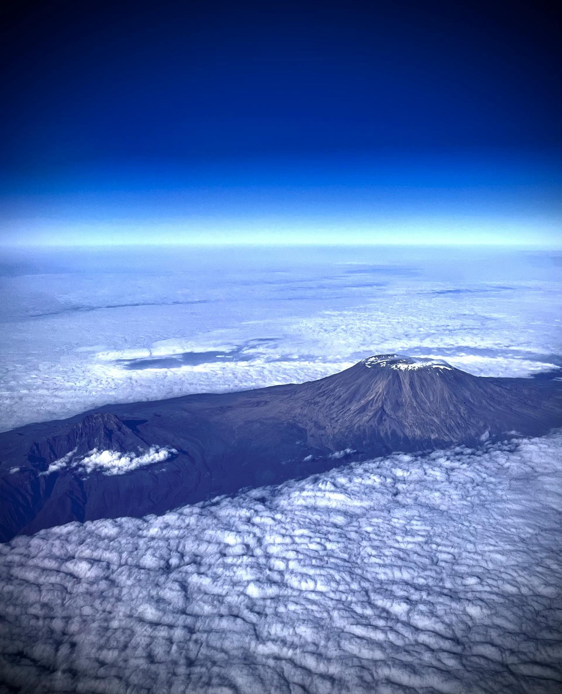
A snow-capped volcanic giant rising from equatorial savanna: Mount Kilimanjaro shouldn’t exist, yet here it stands, defying geography and capturing imaginations for centuries. At 5,895 meters, it’s not just Africa’s highest point but the world’s tallest free-standing mountain, visible from over 100 kilometres away on clear days.
This is Kilimanjaro: geological marvel, ecological wonderland, cultural icon, and one of the Seven Summits you can actually conquer without technical climbing skills. Understanding what makes this mountain extraordinary transforms it from a bucket-list checkbox into an experience that changes everyone who attempts it.
Summit: Uhuru Peak, 5,895m (19,341 feet)—Africa’s highest point
Classification: Dormant stratovolcano (last major eruption ~360,000 years ago)
Location: Northeastern Tanzania, 330km south of the equator
Prominence: ~4,900m vertical rise from base—among Earth’s highest
Base area: 388,500 hectares spanning roughly 70km across
Visibility: Over 100km on clear days; up to 200km from elevated viewpoints
Annual climbers: 35,000-50,000 attempts per year
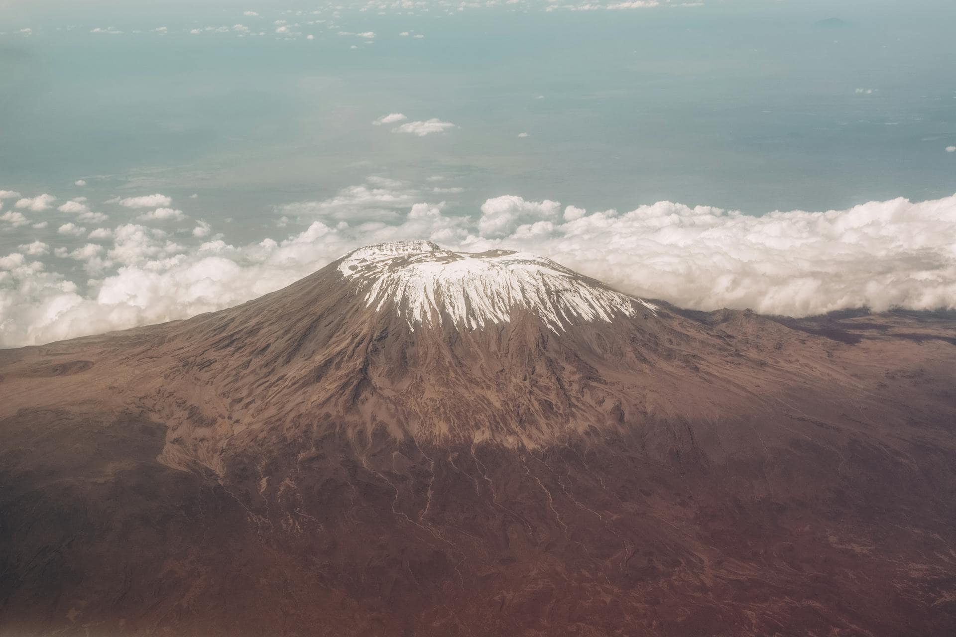
That prominence figure matters: Kilimanjaro rises nearly 5 vertical kilometres from surrounding plains, creating visual drama exceeded only by Denali and select Himalayan peaks. This extreme relief explains why the mountain dominates horizons from impossible distances, its white summit floating above Africa’s endless savannas.
Kilimanjaro owes its existence to continental breakup: specifically, the East African Rift System, where tectonic forces are literally tearing Africa apart. This massive geological feature runs from the Red Sea to Mozambique, creating zones where magma reaches the surface and builds volcanoes.
750,000 years ago: Shira cone begins building through repeated eruptions, eventually reaching perhaps 4,900-5,000m.
500,000 years ago: Shira catastrophically collapses, creating the present plateau. Simultaneously, Mawenzi begins forming eastward.
460,000 years ago: Mawenzi’s volcanic activity ceases after reaching ~5,300-5,400m. Erosion begins its sculpting work.
460,000-360,000 years ago: Kibo cone forms between collapsed Shira and older Mawenzi through multiple eruption episodes—lava flows and explosive eruptions building the stratovolcano structure.
360,000 years ago: Kibo’s last major eruption completes the main cone. Minor subsequent activity shapes the summit crater.
Recent history: Fumarole emissions continue sporadically, confirming Kibo remains dormant rather than extinct.
Understanding Kilimanjaro’s location requires recognising it’s not a single peak but rather a volcanic massif comprising three distinct cones, each with its own geographical position and characteristics.
Kibo, the youngest and highest cone, reaches 5,895 meters at Uhuru Peak, Africa’s highest point. Kibo occupies the centre of the Kilimanjaro massif and forms the mountain’s iconic snow-capped summit that defines its global image. Kibo’s summit features a crater approximately 2.5 kilometres in diameter containing the Reusch Crater, a smaller nested crater that itself contains a central ash pit.
Kibo’s glaciers and ice fields, though rapidly receding due to climate change, remain Kilimanjaro’s most distinctive feature. These glaciers—including the Northern Ice Field, Southern Ice Field, and others—exist because Kibo’s high elevation creates arctic conditions despite its equatorial location.
Mawenzi, located about 5 kilometers east of Kibo, reaches 5,149 meters at its highest point (Hans Meyer Peak). Unlike Kibo’s dome-like profile, Mawenzi features dramatic, jagged peaks and steep rock faces created by extensive erosion. Mawenzi is significantly older than Kibo, and volcanic activity ceased long ago, allowing erosion to carve its distinctive rugged appearance.
Mawenzi is visible from many Kilimanjaro routes, particularly those approaching from the east or traversing the saddle between Kibo and Mawenzi. Its dramatic spires create spectacular photographic subjects and provide technical climbing opportunities for experienced mountaineers, though it’s not part of standard Kilimanjaro trekking routes.
Shira, the oldest cone, collapsed roughly 500,000 years ago, creating the Shira Plateau on Kilimanjaro’s western side. This broad, relatively flat plateau sits at approximately 3,800 meters elevation and spans about 13 kilometers across. The plateau’s volcanic origins are evident in its lava formations, volcanic rock fields, and the Shira Cathedral: a dramatic rocky outcrop rising from the plateau.
The Shira Plateau provides spectacular trekking for routes approaching from the west (Lemosho, Shira). It’s open, moon-like landscapes offer incredible views and excellent acclimatisation opportunities. The plateau represents what remains of Shira’s original volcanic cone after catastrophic collapse aeons ago.
Kilimanjaro’s dramatic elevation creates vertical zonation—five distinct ecological worlds stacked atop each other, each hosting unique communities adapted to specific conditions.
The base: fertile volcanic soils where Chagga communities farm coffee, bananas, and maize. Human settlement dominates, with natural ecosystems largely replaced by agriculture. Those elaborate irrigation channels (mfongo) you’ll notice? Sophisticated water management developed over generations.
Dense tropical rainforest where your climb truly begins. Ancient Ocotea and Podocarpus trees tower 30-40 meters, their branches festooned with epiphytes. Colobus monkeys crash through canopies, turacos flash crimson wings, and occasionally elephants and buffalo roam remote sections.
This zone receives the most rainfall, creating lush, perpetually wet conditions. The forest canopy filters sunlight into green twilight, while ferns carpet the floor and vines create nearly impenetrable tangles.
Trees surrender to surreal alpine landscapes dominated by giant groundsels (Dendrosenecio kilimanjari) and giant lobelias (Lobelia deckenii)—bizarre, Dr. Seuss-like plants evolved specifically for Kilimanjaro’s altitude. Their rosette growth forms and insulating dead leaves protect against freeze-thaw cycles.
Heathers, grasses, and shrubs fill gaps. Wildlife becomes scarce: hyrax (small mammals related to elephants), occasional eland, hardy birds. Endemic Kilimanjaro mice inhabit rocky areas.
Vegetation nearly vanishes. Volcanic rock, scree, and dust dominate landscapes where extreme temperature fluctuations (freezing nights, scorching days), minimal humidity, and intense UV radiation prevent most growth. However, lichens colonize rocks, and hardy grasses survive in sheltered pockets.
Wildlife is rare but persists: occasional leopards documented at extreme altitudes (likely following prey), ravens soaring overhead, spiders somehow surviving on wind-blown insects.
The summit realm: permanent ice and snow (though diminishing), extreme cold, minimal oxygen, virtually no life except microorganisms and occasional wind-transported insects. True arctic conditions at equatorial latitudes—elevation alone creating this impossible world.
Kilimanjaro hosts species evolved specifically for this mountain’s unique conditions, found nowhere else globally:
Loss of these species would represent permanent global biodiversity loss—making Kilimanjaro’s conservation critically important beyond tourism.
The Chagga people have inhabited these slopes for centuries, developing sophisticated agricultural systems utilizing the mountain’s water and volcanic soils. Traditional culture considers Kilimanjaro sacred, woven into creation myths and spiritual practices.
Traditional Chagga homes, built into the mountainside, use efficient multi-story designs adapted to terrain. Those elaborate irrigation systems channel mountain water to agricultural plots—water management sophistication developed over generations.
Other communities—Maasai pastoralists on northern/eastern slopes, Pare people southward—maintain cultural connections, though Chagga have the longest continuous mountain presence.
For Tanzania, Kilimanjaro embodies national pride and identity. The mountain appears on the coat of arms, currency, and national symbols. “Uhuru” means “freedom” in Swahili—Kibo’s summit was renamed Uhuru Peak upon independence in 1961, symbolizing liberation.
The mountain generates substantial tourism revenue, supporting tens of thousands of jobs. Protecting Kilimanjaro represents both environmental conservation and economic necessity.
1848: German missionary Johannes Rebmann becomes the first European reporting the mountain. His claims of equatorial snow spark skepticism—many geographers dismiss reports as impossible.
1861-1862: Baron Carl Claus von der Decken reaches ~4,300m, providing scientific observations and mapping.
1887: Count Sámuel Teleki and Ludwig von Höhnel exceed 5,000m, confirming summit ice fields exist.
October 6, 1889: German geographer Hans Meyer, Austrian climber Ludwig Purtscheller, and Chagga guide Yohani Kinyala Lauwo achieve the first confirmed summit via what’s now the Marangu Route. They name the summit Kaiser Wilhelm Spitze (later Uhuru Peak).
1909-1912: Scientific expeditions study glaciers, geology, and ecology, establishing baseline data still valuable today.
1920s-1930s: Climbing routes develop and standardize. Tourist climbing grows slowly.
1973: Kilimanjaro National Park established, formalizing protection and management.
Present: Approximately 35,000-50,000 annual attempts make Kilimanjaro one of the world’s most climbed major peaks.
Kilimanjaro’s glaciers have become global climate change symbols. The measurements tell a stark story:
Projection: Complete glacier disappearance by 2040-2060, though some ice may persist longer in shaded crater locations.
Causes debated but likely include:
Important note: Glacier loss won’t prevent climbing, Kilimanjaro was summited before glaciers received attention, but represents profound environmental change with symbolic importance for global climate awareness.
Unlike most 5,000+ meter peaks, Kilimanjaro requires no:
This accessibility explains the popularity. Office workers, students, retirees—people from every background successfully summit with adequate preparation and determination.
Don’t mistake “no technical skills required” for “easy”:
Altitude: At 5,895m, atmospheric pressure is ~50% of sea level. Each breath delivers half the oxygen. Altitude sickness affects most climbers to some degree—acclimatization determines success more than fitness.
Duration: 5-9 consecutive days trekking 6-8 hours daily demands sustained cardiovascular endurance and mental stamina.
Summit night: 6-8 hours climbing through darkness, extreme cold (-20°C or colder), and exhaustion to reach sunrise summit.
Descent: After summiting, descend nearly 3,000 vertical meters—punishing tired legs and requiring continued focus despite exhaustion.
Success rates reflect this:
Proper acclimatization time dramatically improves odds.
Tourist Impact: 35,000-50,000 annual climbers create significant stress—trail erosion, waste generation, ecosystem disruption.
Climate Change: Beyond glacier recession, shifting precipitation patterns affect entire ecosystems. Changing ecological zones threaten endemic species adapted to specific altitude bands.
Porter Welfare: Historical exploitation (excessive loads, low wages) led to reforms. Organizations like the Kilimanjaro Porters Assistance Project (KPAP) monitor welfare, though problems persist with unethical operators.
Tanzania National Parks Authority (TANAPA) implements:
Ongoing challenge: Balancing tourism revenue against environmental protection while adapting to climate change impacts.
Kilimanjaro is the world's tallest free-standing mountain—rising nearly 5,000 meters from its base—and Africa's highest peak. It's unique as a 5,895-meter summit requiring no technical climbing skills, making it accessible to fit individuals without mountaineering experience. The equatorial glaciers, five distinct ecological zones from rainforest to arctic conditions, and dramatic prominence create a climbing experience unlike any other major peak.
Yes, Kilimanjaro is a stratovolcano comprising three cones. Kibo (the summit) is dormant, not extinct—fumarole emissions detected as recently as 200 years ago confirm ongoing volcanic activity. However, the last major eruption occurred ~360,000 years ago, and significant eruption in the foreseeable future appears highly unlikely. Scientists monitor the mountain but consider eruption risk minimal.
Extreme altitude creates arctic conditions despite equatorial location. At 5,895 meters, temperatures remain below freezing year-round at the summit, allowing ice to persist. However, these glaciers are rapidly receding—from 12 square kilometers in 1912 to less than 2 square kilometers today—and may disappear by 2040-2060 due to climate change.
Approximately 35,000-50,000 people attempt Kilimanjaro annually, making it one of the world's most climbed major peaks. Overall success rates range from 65-75% for shorter routes (5-6 days) to 85-95% for longer routes (7-9 days) that allow better acclimatization. About 30,000-40,000 people successfully summit each year.
Lower rainforest zones host colobus monkeys, blue monkeys, bushbuck, duiker, diverse bird species (turacos, hornbills), and occasionally elephants and buffalo. Higher elevations support hyrax, eland, endemic Kilimanjaro mice, and hardy birds. Remarkably, leopards have been documented at extreme altitudes. The mountain also hosts endemic species found nowhere else on Earth, including unique plants, shrews, and bats.
No technical mountaineering skills required—no rock climbing, ice climbing, or rope work. However, don't mistake accessibility for ease. The 5,895-meter altitude creates severe challenges through reduced oxygen (~50% of sea level), and the multi-day trek demands strong cardiovascular fitness and mental determination. Physical preparation and proper acclimatization are essential for success.
Kilimanjaro is a national symbol appearing on Tanzania's coat of arms and currency. "Uhuru Peak" means "Freedom Peak"—renamed upon independence in 1961 to symbolize liberation. The mountain generates substantial tourism revenue supporting tens of thousands of jobs and serves as a critical water source for surrounding regions. It embodies both cultural significance and economic importance for Tanzania.
We believe adventure should inspire, not exploit. Every expedition we guide creates meaningful employment for local families, supports community development, and preserves the natural wonders we’re privileged to explore.
* Sign up to receive curated travel ideas, seasonal discounts.
Copyright © 2025 All Rights Reserved.